
CUSTOMERS
Our customers inspire us to do what we do.
ORGANIZATIONS WE HAVE WORKED WITH

Academia Sinica
Central Weather Administration, Taiwan
China Earthquake Administration
Department of Mineral Resources, Thailand
Geophysical Earth Observatory for Ice Covered Environments
The DOMERAPI Project
Fundación Venezolana di Investigaciones Sismológicas
Geophysical Institute of Peru
GFZ German Research Centre for Geosciences
Incorporated Research Institutions for Seismology
Japan International Cooperation Agency

Korea Institute of Geoscience

Korea Institute of Nuclear Safety

Korea Meteorological Administration

Korea Polar Research Institute
Laser Interferometer Gravitational Wave Observatory
National Taiwan University, Department of Geosciences
Natural Resources Canada
Ocean Networks Canada
Pacific Northwest Seismic Network
Sandia National Laboratories
Philippine Institute of Volcanology and Seismology
Royal Irrigation Department, Thailand
Scripps Institute of Oceanography
Tonga’s Geological Services
US Department of Energy
United States Geological Survey
University of Brasilia
University of Oslo
Wadia Institute of Himalayan Geology
Woods Hole Oceanographic Institution
PROJECTS WE HAVE WORKED ON
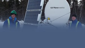
GEOICE, led by Jeremy Paul Winberry of Central Washington University, will provide increased observational capabilities and logistical efficiencies needed to seismically image the structures and dynamic behavior of both the solid Earth and overlying ice in remote ice-covered regions. Nanometrics Meridian Compact postholes were deployed at Taku Glacier, Alaska during the summer of 2015 and retrieved during the summer of 2016.
Geophysical Earth Observatory for Ice Covered Environments (GEOICE)
The Transportable Array (TA) is one of four key observatories that make up IRIS’s Earthscope USArray. The TA is a network of 400 broadband seismographs and atmospheric sensors that have been operated at temporary sites across the United States from west to east in a regular grid pattern, beginning in August 2007. The Transportable Array is currently using Trillium 120 vault seismometers, Trillium 240 vault seismometers, Trillium 120 posthole seismometers and Titan accelerometers.
Incorporated Research Institutions for Seismology (IRIS)
LIGO first approached Nanometrics in 2008 while preparing for the overhaul of their existing detectors, set to begin in 2010. LIGO needed instrumentation that would be exceptionally reliable as the detectors were to be embedded deep within the innards of kilometres of vacuum tunnels. Any repair job could take months to complete. We eagerly accepted the custom engineering project, adjusting the Trillium 240 for LIGO’s needs, walking them through the technology and helping with the testing. The final product was delivered in 2010, the year LIGO began their four-year redesign of their interferometers. The new sensors were 10 times more sensitive than the previous versions, and were successful within mere days of their first use. We are thrilled to have been part of this landmark scientific discovery.
Laser Interferometer Gravitational Wave Observatory (LIGO)
In 2016, Natural Resources Canada chose Nanometrics to recapitalize and modernize the equipment used in the Canadian National Seismograph Network, a cross-Canada network operated by the Geological Survey of Canada. The $4.6 million contract includes the purchase of Trillium 120 QA seismometers for monitoring regional seismicity, Titan accelerometers for monitoring strong ground motion, Centaur digitizers, associated software and training.
Natural Resources Canada
In February 2016, the Government of British Columbia announced an investment of $5 million for the development of an earthquake early warning system for southwestern British Columbia. The first sensor, deployed in June 2016, is a Titan accelerometer, encased in a glass sphere to withstand the pressure in water depths of 850 m at Barkley Canyon, off the southern coast of British Columbia. The system will be installed, tested and delivered to Emergency Management BC by March 2019.
Oceans Networks Canada (Early Warning Network)
The PNSN is a joint venture of the University of Washington and the University of Oregon that monitors earthquake and volcanic activity across the Pacific Northwest. The network is the second-largest in the US, consisting of over 300 stations. The network features both TitanSMA strong-motion accelerographs and Trillium Cascadias.
Pacific Northwest Seismic Network (PNSN)
The Permafrost Active Layer Seismic Interferometry Experiment was conducted at the Poker Flat Research Range in Fairbanks, Alaska by Robert Abbott and Hunter Knox of the Sandia National Laboratories in Albuquerque, New Mexico. The experiment was designed to monitor changes in active layer thickness in real time. Data are derived primarily from seismic data streaming from seven Nanometrics Trillium Posthole seismometers directly buried in the upper section of the permafrost. Results from the Horizontal to Vertical Spectral Ratio (HVSR) analysis shows the method’s effectiveness at determining the active layer’s thickness with a single station.
Sandia National Laboratories
Nanometrics original move into the OBS market segment came when SCRIPPS selected the Trillium 240 seismometer (a legacy product) for their deep long-term deployment OBS fleet. Multiple one year deployments of the SCRIPPS systems demonstrated the exceptional performance of these systems with >99.9% data availability from the sensor packages over all deployments. SCRIPPS and Woods Hole selected the Trillium Compact for the Cascadia OBS initiative.
Scripps Institute of Oceanography
After five decades of nuclear weapons production at the Hanford Site in Washington state, one of the largest nuclear cleanup efforts in the world began in 1989. The Hanford Seismic Network, supplemented by the Eastern Washington Regional Network, features the Trillium Cascadia, which measures both strong and weak motion in a single instrument. The data collected is published and used by Hanford Site contractors involved in waste management, natural phenomena hazards assessments, and engineering design and construction.
US Department of Energy
We are proud of our long-standing relationship with the United States Geological Survey (USGS), the world’s principal global source of data and information for earthquake locations, earthquake hazard mitigation and earthquake emergency response. We were awarded our first five-year call-off contract with USGS in 2010. The second five-year call-off contract was awarded in 2016. USGS operates the Advanced National Seismic System across the US and, in partnership with IRIS, the 150+ station Global Seismic Network, which includes many Nanometrics seismometers. Most recently, USGS has ordered several Trillium 360 seismometers, in vault, posthole and borehole form factors.
United States Geological Survey
The SEISMOGLAC project, led by Andreas Köhler, Department of Geosciences, University of Oslo, contributed to the improved understanding of processes such as iceberg calving and glacier surging using seismic data as they relate to climate change. Thirteen years of data from permanent stations on the Arctic archipelago of Svalbard supplemented data from a temporary array including Trillium 120 PA’s deployed between May and mid-September 2013.
University of Oslo
M. Jeffrey Mei from Woods Hole Oceanographic Institute and MIT and his team developed a multiple-station technique for localizing glacier calving events was applied to Helheim Glacier in southeastern Greenland. Using the seismic data from Nanometrics Trillium 120 and three Nanometrics Trillium 240 broadband seismometers, researchers generated a catalogue of 11 calving locations, showing that calving preferentially happens at the northern end of Helheim Glacier.
Woods Hole Oceanographic Institute
CASE STUDIES
For a full list of our case studies please visit our resources page.
TOUCH
Mission Critical Seismic Network CQ Net
Mission Critical Seismic Network CQ NetRead the case study
TOUCH
Monitoring natural & induced seismicity in Horn River Basin
Monitoring natural & induced seismicity in Horn River BasinRead the case study
TOUCH
Replacing Puerto Rico's Seismic Network
Replacing Puerto Rico's Seismic NetworkRead the case study