
Celebrating the 10-Year Anniversary of The First National Seismic Network for the Maltese Islands
https://seismic.research.um.edu.mt/
PROJECT BACKGROUND
The Department of Geosciences Needed to Understand and Monitor National Seismic Hazards, Earthquake Site Response and Earthquake Risks
The population living on the Malta Archipelago regularly feel seismicity from local earthquakes originating from the seismically active Sicily Channel, as well as from regional moderate earthquakes from Sicily, Greece or the Ionian Sea. Until 2014, the Department of Geosciences only had one broadband station operating on the island (WDD, Wied Dalam) and it was demonstrated that seismic activity was occurring more than previously thought. This one station was not sufficient for the public hazard and seismicity research requirements.
A single station is insufficient to determine the event origin and epicenter of an earthquake. A minimum of three stations are required to triangulate the data and a fourth station would provide event depth. Prior to the installation of the MSN network, in order to locate local events, the geoscientists at the University of Malta would have depended on obtaining data from nearby regional networks that make earthquake data publicly available. This method would have resulted in less accurate quantification of the event source parameters and accuracy would have been diluted.
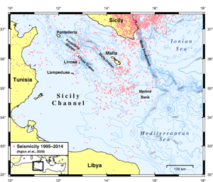
“Seismicity around Malta and in the Sicily Channel. Pink dots represent the seismicity between 1995 and 2014, compiled from regional catalogs and high‐quality single‐station locations (Agius et al., 2020). Magnitudes range between 2.0 and 4.9. Contours show the bathymetry at 250 m intervals. The inset shows the study area on a regional map.”
Source: A First National Seismic Network for the Maltese Islands—The Malta Seismic Network Available, Pauline Galea; Matthew R. Agius; George Bozionelos; Sebastiano D’Amico; Daniela Farrugia, SRL | Research Article | March 31, 2021
Image courtesy of University of Malta.

CHALLENGES
Anthropogenic Noise, Clay and Small Islands
There were other concerns that needed to be addressed. The islands were undergoing rapid building and infrastructure development and the geology posed additional hazards. Much of the geology of the Malta Archipelago has a vulnerable underlay of clay stratum which is known to amplify the effects of seismicity. Combined with rapid building development, the seismic risk to the population was a concern and the need for understanding the microseismicity was also apparent. Additionally, given that measuring seismicity on small islands is difficult with anthropogenic noise due to condensed urbanization, highly sensitive instruments were needed.
SOLUTION
The Setup of a Seismic Network
In 2015 the Seismic Monitoring & Research Group (SMRG) was established within the Department of Geoscience. Over a period of six years, the group developed the Malta Seismic Network (MSN), a national network of broadband seismic stations located on the three major islands of the Maltese archipelago—Malta, Gozo, and Comino. The new stations comprised Centaur data loggers and Trillium 120 (Compact / 120PA) 3-channel broadband seismometers to complete a network of 8 stations in total that cover 300 square kilometers. The group plan to enhance the network by adding additional stations in the near future.
All stations transmit data in real time to the Department of Geosciences, University of Malta. The MSN monitors and evaluates seismicity and microseismicity around the islands, and the SMRG team carries out seismotectonic studies, seismic hazard, crustal structure, seismic site response and ambient noise studies.
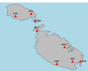
Pictured right: Malta Seismic Network, Map of Malta with Station locations
(note HQIM & WDD stations do not contain Nanometrics instrumentation.)
Image courtesy of University of Malta.


“For us, Nanometrics is an important partner since the Malta Seismic Network operates by using their sensors and data loggers.
We would also like to take this opportunity to sincerely thank Nanometrics for the consistent quality and reliability of their products, which have been essential in maintaining our operations over the years. Their products have contributed significantly to our ability to conduct research and fieldwork effectively.”
RESULTS
Improved Study of Seismic Hazards on the Malta Archipelago
Today, the MSN monitors regional seismic activity, especially previously undetected/unlocated microearthquake activity and earthquake sequences within a distance of 150km in the central Mediterranean. The residents of Malta are now well-served as the MSN provides National Seismic Hazard information to the Department of Civil Protection. The seismic data is shared worldwide with FDSN and Earthscope as well as INGV and other Central Mediterranean seismic networks for improved data of completeness. The Department of Geoscience has enriched data sets for seismic research, for earthquake site response and earthquake risk research.
For full details read the SMRG team’s article in SRL, Geosciences :
A First National Seismic Network for the Maltese Islands—The Malta Seismic Network Available
Pauline Galea; Matthew R. Agius; George Bozionelos; Sebastiano D’Amico; Daniela Farrugia
SRL | Research Article| March 31, 2021

One LAST NOTE . . .
Currently, the majority of the world’s seismic networks are located on land.
Given that the oceans cover 71% of the Earth’s surface, the geoscience community is expanding their networks to the ocean bottom. They are now beginning to reap the benefits of extending the boundaries of scientific observations offshore, which improves early warning and tsunami systems, and provides improved data towards better understanding the Earth’s lithosphere, for example. Learn more about Atlantis Ocean Bottom Seismic solutions portfolio.